 Catalogue PIGMA
Agricultural and aquaculture facilities
Type of resources
Available actions
Topics
Keywords
Contact for the resource
Provided by
Years
Formats
Representation types
Update frequencies
status
Scale
Resolution
-
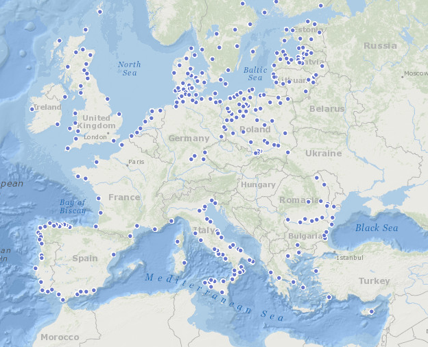
This map shows the different Fisheries Local Action Groups (FLAGs) mobilised by the implementation of Axis 4 of the European Fisheries Fund (EFF) to design and implement integrated local development strategies for the sustainable development of fisheries areas. The FARNET Support Unit acts as a platform for networking between fisheries areas and as support for the FLAGs. Links to related websites are displayed when a FLAG is clicked.
-

Cartographie montrant la répartition des ateliers de productions dans le projet d'installation de jeunes agriculteurs.
-
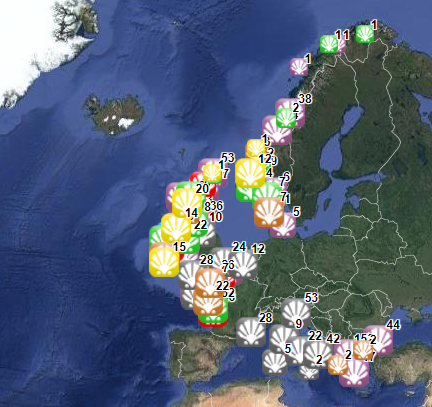
This dataset stems from the Joint Research Centre (JRC) Biomass Mandate (https://knowledge4policy.ec.europa.eu/projects-activities/jrc-biomass-mandate_en) and it is available for viewing and download on EMODnet - Human Activities web portal (www.emodnet-humanactivities.eu) and on the platform from the European Commission’s Knowledge Centre for Bioeconomy (https://knowledge4policy.ec.europa.eu/visualisation/bioeconomy-different-countries_en#algae_prod_plants). Its aim is to build a reliable database to characterize the algae sector and to support informed European policies on Blue Growth and Bioeconomy. More detailed information on the Status of the Algae Production Industry in Europe can be found in a JRC-led study published in Frontiers in Marine Science (https://publications.jrc.ec.europa.eu/repository/handle/JRC122250). Information on the location (geographic coordinates) of the production facilities, group of produced organism (macroalgae, microalgae and spirulina), production method (Fermenters, Harvesting , Photobioreactors, Open ponds, Semi Open ponds, land-based or at sea Aquaculture, Integrated multi-trophic or not) and species (see dataset) have been collected in the following countries: Austria, Belgium, Bulgaria, Croatia, Czech Republic, Denmark, Estonia, Faroe Islands, France, Germany, Greece, Greenland, Hungary, Iceland, Ireland, Italy, Latvia, the Netherlands, Norway, Portugal, Spain, Sweden, Switzerland and the UK. In November 2021, the JRC has updated the database with the latest information on the production units operational at the time.
-
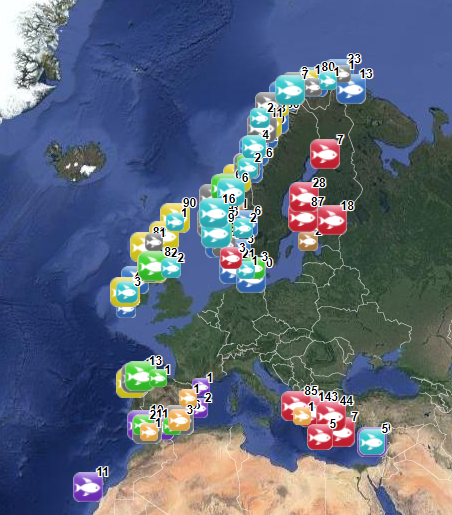
The database on marine finfish aquaculture in the EU was created in 2017 by AND-International for the European Marine Observation and Data Network (EMODnet). The dataset provides information about the location of marine finfish farms in the EU and partner countries where data are available. There is an obligation for EU MS to inventory all authorized aquaculture sites under the Council Directive 2006/88/EC on animal health requirements. Despite this obligation, the availability of data varies among MS from no data available at all to a complete regularly updated dataset (e.g.in Ireland). As far as partner countries are concerned, data have been collected only in Norway and the UK (Scotland only) at this stage, where detailed data are provided online. Data provided here cover Cyprus, Danmark, Finland, Greece, Ireland, Malta, Norway, Spain and the UK (Scotland only). Data collection is still undergoing in other EU MS and neighbouring countries. Each point has the following attributes (where available): Country, Owner name, Status (Active, Expired, Inactive, Renewal, n.a.), Farm type (Flatfish, Diversified farm, Other specialised farm, Salmon, Salmonids, Seabass-seabream, Trout,Tuna, n.a.), Production method (Sea cages, Saltwater tanks/raceways, Saltwater ponds, Saltwater closed (recirculation), Quarantine, Other, n.a.), Production stage (Grow out for human consumption, Hatchery, Nursery, Brood stock, Reproduction, Restoration of wild stock, Put and take fisheries, Processing facility, Salughtering facility, Other, n.a.), Purpose (Commercial, Restocking, Other, n.a.), Products detailed (detailed product information names as presented in the source and translated to English), Point information (Polygon centroid, Original) depending on how the information is provided in the source (polygons or points), Site_ID. The farm type relies on a typology established by AND-International, based on available information on species grown. A relational table provides harmonised information about species grown using Eurostat nomenclature for the Species Group (Cods, hakes, haddocks; Flounders, halibuts, soles; Miscellaneous coastal fishes, Miscellaneous demersal fishes; Miscellaneous pelagic fishes; Salmons, trouts, smelts;Tunas, bonitos, billfishes), the species name (commercial and scientific) and the code. Compared with the previous version this new version has been not only updated but was also reviewed (dataset schema and attributes values), in order to add information on production methods, production stages and purposes and to provide a more useful typology based on species grown.
-
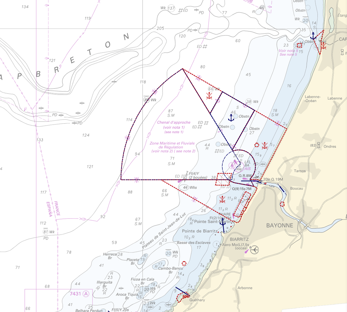
"Regulation - Navigation" product contains 18 object classes, the acronyms used are those of IHO standard S-57 - International Hydrographic Organization – (https://iho.int/): - Anchorage area (ACHARE): an area in which vessels anchor or may anchor. - Anchor berth (ACHBRT): a designated area of water where a single vessel, sea plane, etc. may anchor. - Administration Area (Named) (ADMARE) - Cable area (CBLARE) - Coastguard station (CGUSTA) - Cargo transhipment area (CTSARE) - Distance mark (DISMAR): mark indicating the distance on canals or rivers. - Dumping ground (DMPGRD): sea area where dredged material or other potentially more harmful material e.g. explosives, chemical waste, is deliberately deposited. - Fairway (FAIRWY): part of a river, harbour etc. where the main navigable channel for vessels of larger size lies. It is also the usual course followed by vessels entering or leaving harbours and sometimes called "ship channel". - Ice area (over land or water) (ICEARE) - Local magnetic anomaly (LOCMAG): anomaly of the magnetic field of the earth, extending over a relatively small area, due to local magnetic influences. - Marine farm/culture (MARCUL) - Navigation line (NAVLNE): a line generally passing through two clearly defined charted landmarks, and along part of which a vessel can approach safely. - Pipeline area (PIPARE) - Recommended track (RECTRC): track of undefined width, recommended to all or only certain vessels. - Restricted area (RESARE): specified area designated by an appropriate authority within which navigation is restricted in accordance with certain specified conditions. - Sea-plane landing area (SPLARE) Detailed definitions of each of these object classes can be found in the S-57 standard (https://iho.int/en/standards-and-specifications). An online catalog is available at http://www.s-57.com/. Some of the symbols used for display on data.shom.fr portal have been adapted from icons from the OpenSeaMap open library (https://github.com/OpenNauticalChart/). For reasons of readability, not all the characteristics of the objects are systematically displayed. All available information can be consulted by querying this layer.
-
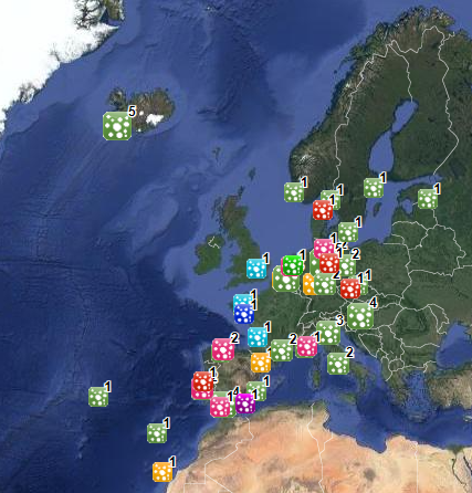
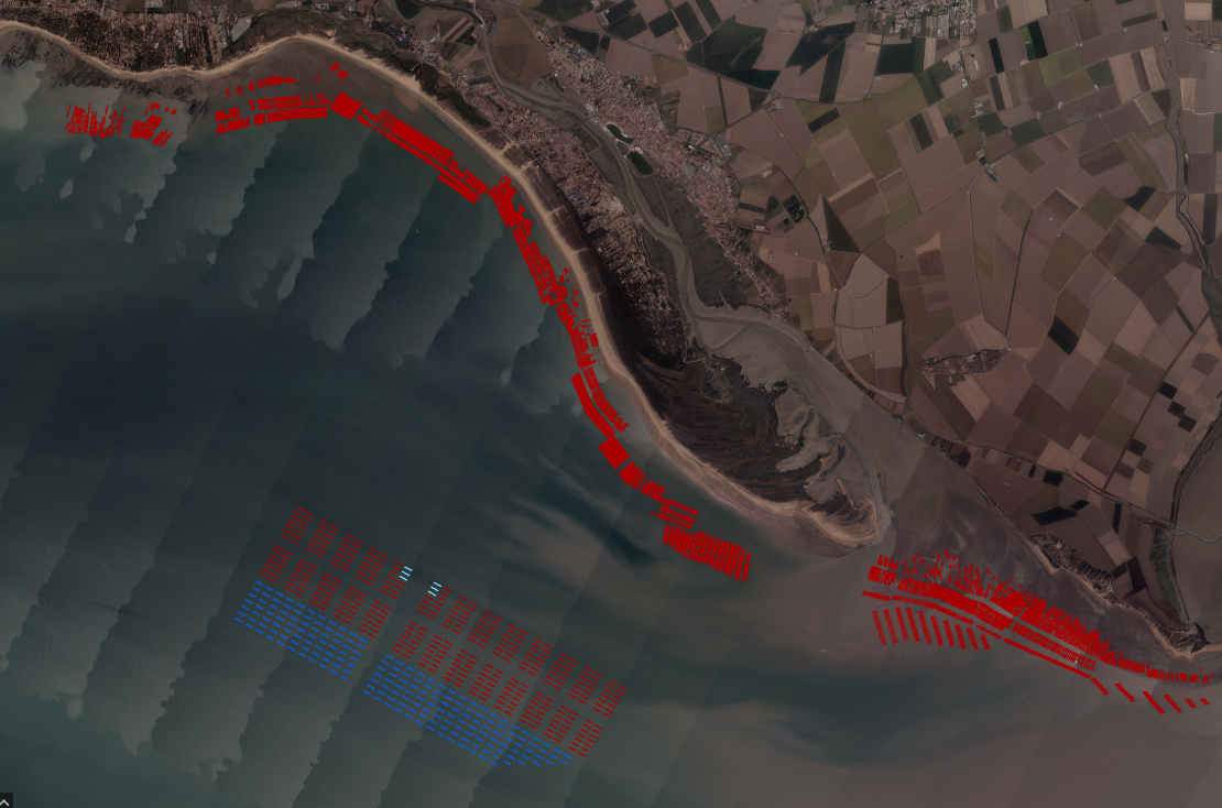
The database on shellfish aquaculture in the EU was created in 2014 by AND-International for the European Marine Observation and Data Network (EMODnet). It is the result of the aggregation and harmonization of datasets provided by national sources across the EU (plus Norway) and by the project Euroshell. Data are available for viewing and download on EMODnet - Human Activities web portal (www.emodnet-humanactivities.eu). The database contains points representing shellfish farms or shellfish production areas (depending on available data) in the following countries: Bulgaria, Denmark, France, Greece, Ireland, Italy, Netherlands, Norway and United Kingdom. Spanish data is provided separately through WMS services. Data is missing for Germany, Portugal, Sweden, Croatia and Slovenia. Except for Germany, the shellfish production remains limited in those MS. There is no production in other MS. Each point has the following attributes (where available): status (active, inactive), country, owner name, farm type (Mussels, Oysters, Mussels-Oysters, Clams, Specialised (other), Mixed (other)), production method (Long lines, Trestles or trays, Tanks, Rafts, Beds, Raceways), production stage (Grow out for human consumption, Hatchery, Nursery, Broodstock, Reproduction, Harvest, Other), purpose (Commercial, Research, Education, Display, Other), species detailed (English translation of the information provided on species grown or authorised in the source), point information (Polygon centroid, Original) depending on how the information is provided in the source (polygons or points), site_id, distance to coast (metres), position from coastline (At sea, within the coastline). The farm type relies on a typology established by AND-International, based on available information on species grown or authorised. A relational table provides harmonised information about species grown or authorised using Eurostat nomenclature for the Species Group (Mussels; Oysters; Clams, cockles, arkshells; Scallops, pectens; Abalones, winkles, conchs; Sea-urchins and other echinoderms) and when available the species name (e.g. Blue mussels - Mytilus edulis). The distance to coast (EEA coastline shapefile) has been calculated using the original data map projections, where available. In the other cases it was used the UTM WGS84 Zone projected coordinate system where data fall in. Compared with the previous version this new version has been not only updated but was also reviewed (dataset schema and attributes values), in order to add information on production methods, production stages and purposes and to provide a more useful typology based on species grown. Data from Norway and Bulgaria have been added. Data from France relies on cadastral data rather than large production areas in the previous database.
-
-

Cartographie des établissements publics ayant choisi d'adhérer à la charte Manger Bio&Local, Labels et Terroir. Cartographie réalisée par géocodage avec le batch géocodeur en ligne et reprise des éléments non géocodés de manière manuelle (Google maps et pages blanches/jaunes)
-

Cartographie de l'Aide du département des Pyrénées Atlantiques à l'installation des Jeunes Agriculteurs (AJA)
-

Cartographie de la répartition des investissements mécaniques en zone de montagne par cantons.